

October 14, 2026 - 10:00 a.m.
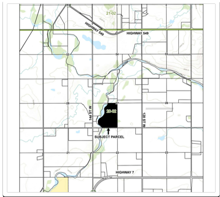
Loscher - SW 27-20-02 W5M - Redesignation
Foothills County has received an application from agent Jeff Badke of Badke Consulting on behalf of landowners Matthew & Kari Loscher proposing the Redesignation of the subject 104.7 acre Natural Resource Extraction (INR) District Parcel to Agricultural District, and a site specific amendment to Section 10.17.3 of the Land Use Bylaw to relax the minimum separation distance between a dwelling and a natural resource extraction operation from 100.0 m to 20.0 m.
As shown on the location map, the subject parcel (shaded in black) is located within Council Division 2, approximately 1.63 km north of Highway 7, approximately 0.17 km east of 144 Street W, approximately 2.26 km south of Highway 549, and approximately 2.43 km west of 112 Street W.
October 14, 2026 - 11:00 a.m.
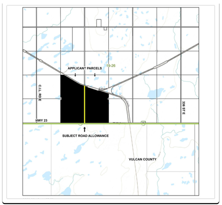
JGL Livestock - E 05-19-26 W4M - Road Closure for Purchase of Undeveloped Road Allowance
Foothills County has received an application from JGL Livestock proposing to Purchase an Undeveloped Road Allowance. Access will be denied.
As shown on the location map, the subject parcels (shaded in black) are located within Council Division 1, directly north and adjacent to Highway 23 and the boundary of Vulcan County, approximately 1.62 km east of C.I.L Road E, and approximately 3.27 km west of 336 Street E.
October 14, 2026 - 1:30 p.m.
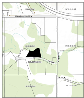
E.T. Equities - NE 20-22-03 W5M - Redesignation
Foothills County has received an application from E.T. Equities proposing the removal of the Municipal Reserve designation for the purpose of sale, and to have the 4.62 acre subject parcel zoned to Country Residential District. The purpose of the proposed zoning is to allow for the consolidation of the parcel into the surrounding land.
As shown on the location map, the subject parcel (shaded in black) is located within Council Division 4, directly north and adjacent to 184 Avenue W, approximately 0.24 km west of 256 Street W, and approximately 0.45 km south of Priddis Greens Drive W.
October 21, 2026 - 10:00 a.m.
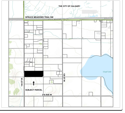
Amiri/White - NW 15-22-02 W5M - Redesignation
Foothills County has received an application from agent Robyn Erhardt of Township Planning + Design Inc. on behalf of landowners Hamed Amiri & Marnie White proposing a redesignation of a 6.5 +/- acre portion of the subject 50 acre Agricultural District parcel to Country Residential District to allow for the future subdivision of one 6.5 +/- acre Country Residential lot.
As shown on the location map, the subject parcel (shaded in black) is located within Council Division 5, directly east and adjacent to 144 Street W, approximately 0.80 km west of 128 Street W, approximately 0.80 km north of 210 Avenue W, and approximately 2.17 km south of Spruce Meadows Trail SW.
October 21, 2026 - 11:00 a.m.
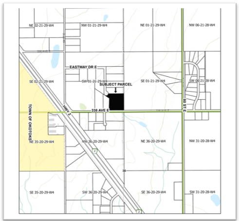
Cabrera/East West Renovations Ltd. - SW 01-21-29 W4M - Amend CR
Foothills County has received an application from agent Jeff Badke of Badke Consulting Ltd. on behalf of landowner Obanel Espejel Cabrera of East-West Renovations Ltd. proposing an amendment to the Country Residential District land use rules to allow for the future subdivision of 1 new 5.54 +/- acre Country Residential Sub-District "A" lot.
As shown on the location map, the subject parcel (shaded in black) is located within Council Division 7, directly north adjacent to 338 Avenue E, approximately 0.63 km east of Highway 2, approximately 0.81 km west of 80 Street E, and directly southeast and adjacent to Eastway Drive E.
View instructions on how to participate.
View the Council meeting agenda.
October 21, 2026 - 1:30 p.m.
Amendment to Land Use Bylaw 60/2014 and Redesignation
Foothills County is holding a public hearing for two concurrent applications.
APPLICATION FOR AMENDMENTS TO THE DIRECT CONTROL DISTRICT #34 (DC#34)
The proposed amendments to Direct Control District #34 include:
Expanding the purpose and intent of the district to allow utility-scale energy generation facilities and associated infrastructure, including commercial renewable energy systems and utility power generation facilities;
Changing Utility Services, Major from a permitted use to a discretionary use; and
Making minor amendments to the district regulations to align with the expanded purpose and intent.
APPLICATION FOR REDESIGNATION
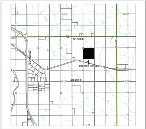
An application has been submitted by NVS Engineering on behalf of Journey Energy Inc. to redesignate approximately 9.74 acres within SE 35-19-28 W4M from the Agricultural District to Direct Control District #34 (DC#34) to enable the applicants to apply for development approval to allow for the operation of an existing 16.5 MW natural gas power generation facility situated on the site. No subdivision is proposed as part of this application.
As shown on the location map, the subject lands (shaded in black) are located approximately 4 km (2.5 miles) east of Highway 2, 0.8 km (one-half mile) south of 434 Avenue E, on the west side of 160 Street E, within Council Division 1.
October 28, 2026 - 1:30 p.m.
Amendment to the Heritage Pointe Area Structure Plan - SW 05-22-29 W4M - Redesignation, and Site-Specific Amendments
Foothills County has received an application from agent Kristi Beunder of Township Planning + Design Inc. on behalf of landowners Serenity Land Corp. for an amendment to the Heritage Pointe Area Structure Plan (ASP) and a concurrent land use redesignation application with site-specific amendments.
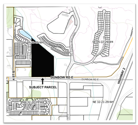
The proposed ASP amendment contemplates the addition of a new development cell (referred to as Serenity Phase III and Cell F) and a request to include the lands within the Heritage Pointe ASP plan area. The subject 20.68 acre parcel, legally described as SW 05-22-29 W4M; Plan 9011402, Block 1, is currently zoned as Country Residential District. The new development cell is proposed to facilitate the future development of 52 Residential Community District lots. All lots are proposed to be serviced with piped water and wastewater from the existing Bluestem Utilities facilities that currently service the balance of the Hamlet of Heritage Pointe.
The concurrent land use redesignation application proposes to redesignate the subject 20.68-acre lands from Country Residential District to Residential Community District, with additional lands dedicated as Municipal Reserve, Environmental Reserve and Public Utility. In addition, Site-Specific Amendments are proposed to address setbacks and lot coverage.
As shown on the location map, the subject parcel (shaded in black) is located within Council Division 6, directly north and adjacent to Dunbow Road E, approximately 0.20 km east of 4 Street E, and approximately 0.79 km west of Highway 2.
View instructions on how to participate.
View staff report.
View the Council meeting agenda.
Heritage Pointe Area Structure Plan (ASP) | Foothills County
Heritage Pointe Area Structure Plan (ASP) Addendum - SERENITY | Foothills County